
Finding a Winchester Street by Address
Begin an address-history trail with the city lookup, then keep the displayed address, ZIP, parcel identifier, tax-map key, locality layer, and access date together. The property card is an assessment record, so it can point to an owner field and sale history without proving that every person connected to the address lived there. The next record has to answer the next question. A deed establishes a transfer, while a dated directory or newspaper may identify an occupant or business at a particular time.
Winchester is an independent city and Frederick County's seat, so a Winchester mailing label does not settle jurisdiction. Check the city map's Corporate Limits and Frederick County layers before following a city parcel into a clerk search. An outlying address may need the separate Frederick County assessment and clerk route, even when its postal city reads Winchester.
- Enter the complete address in the Vision Property Lookup and select its normalized result.
- Save the PID, tax map or MBLU key, owner field, sale or history fields, and the situs address shown on the card.
- Open the Winchester property viewer to inspect the parcel, street, footprint, zoning, and locality layers.
- Use the legal description and parties to request or search the recorded deed through the proper circuit clerk channel.
- For an older address trail, ask Handley Archives for the relevant directory year, street-list pages, newspapers, maps, or address-filed photographs.
Note: Keep each name labeled as an assessed owner, deed party, directory occupant, or newspaper subject rather than turning mixed records into a current roster.
Winchester Street Directory Search Fields
The Vision screen offers a practical starting point for an address lookup because it separates an address from an owner name and a map key. Address mode uses autocomplete and currently requires at least three characters. Owner mode asks for a last name. Parcel number, Tax Map, Vision PID, and All modes provide alternate ways to recover a known parcel. Use the field that matches the record already in hand instead of relying on a broad name search.
| Vision control | Entry format | Street-research use |
|---|---|---|
| Address | Autocomplete, at least three characters | Select the standardized street result and PID. |
| Owner | Owner last name | Locate a possible assessment card, then verify by address. |
| Parcel # | Account or parcel number | Open a known parcel directly. |
| Tax Map | Map, Block, Lot, Unit | Preserve the MBLU key when an address is uncertain. |
| Vision PID | Portal identifier | Return to the exact city property card. |
| All | Any text value | Use cautiously when a field-specific search fails. |
The City Hall card is a useful public example of the field structure. The Commissioner of the Revenue oversees the city real-estate assessment function, while Vision supplies the web lookup.
For a street record, the assessment office and the Vision card are starting points, not substitutes for a recorded deed or proof of present occupancy.
Winchester Streets and Locality Layers
The city GIS provides more than a parcel outline. Its documented layers include parcels, streets, building footprints, railroad, contours, streams, wetlands, historic district, zoning, Corporate Limits, and Frederick County. A street-by-street search can use those layers to determine whether a record belongs on the city side of the line before sending a request to a city office. The map also supplies context when a lot, drainage pattern, or historic-district boundary explains an unusual parcel shape.
Do not assume that a city map offers a ready-made household list. The captured materials did not identify a written radius or buffer feature. Pan and identify individual parcels as needed, then use the parcel key to locate the correct assessment or deed record. The 1971 annexation is another reason to preserve the year of every record: a historic deed or directory can use a different legal locality for the same physical area.
Winchester Address Records by Street
Address-keyed sources answer different parts of a street-record question. The assessment card links a site to the city tax map. GIS describes the mapped context. The circuit clerk holds instruments that record transfers. Handley materials place a person, business, or structure at an address in a dated publication or image. A focused city request can fill a gap for an existing permit or planning file when no public search box exposes it.
| Address record | Custodian | What it can establish | Access route |
|---|---|---|---|
| Assessment card | City Commissioner and Vision | Situs, PID, tax map, owner field, value, building and sale fields | Free online lookup; office assistance |
| Parcel and planning map | Winchester GIS | Parcel, structure, street, zoning, limits, and environmental layers | Interactive viewer and REST catalog |
| Recorded deed | Winchester Circuit Clerk | Grantor, grantee, date, book or page, legal description, and easements | Clerk counter, subscriber remote access, or request channel |
| Directory or newspaper | Handley Archives | Dated address, occupant, business, notice, or event reference | Reading room, microfilm, database, or reference request |
| Permit or zoning file | City department | Existing plans, permits, inspections, or cases when releasable | Department request or city FOIA |
A parcel is the mapped piece of land. The situs address is the property location shown for assessment, which can differ from an owner's mailing address. An MBLU is Vision's compact map, block, lot, and unit key. A criss-cross directory would organize addresses back to names, but Handley confirms only occasional street lists in its city-directory volumes, not a specific standalone series. The Winchester City Directory collections explain how to request the dated volumes without assuming a reverse run exists.
- Parcel
- A mapped land unit tied to assessment and tax-map information.
- Situs address
- The property location used on an assessment record, separate from a mailing address.
- MBLU
- A map, block, lot, and unit key shown by Vision; retain its spaces and slashes.
- Criss-cross directory
- An address-to-name arrangement; request it from the archive rather than presuming a documented local run.
Winchester Permit Records by Address
Building, planning, fire, engineering, and selected special-event applications moved to the city's OpenGov permitting and licensing platform on April 1, 2025. The captured public material did not expose a street-wide or ZIP-wide record index. For a historical property question, name the address and date range, then request the existing permit, final inspection, site plan, or zoning file from the responsible city office. Do not ask an office to create a new narrative or a new list.
The city accepts FOIA requests through its online route as well as email, mail, fax, phone, or an in-person request. Virginia FOIA uses a five-working-day response framework, permits redaction or other statutory responses, and may involve actual search, review, copying, or delivery costs. Ask for electronic delivery where possible and confirm charges before pursuing a large file set.
The city permits and licensing page is the current routing point for the platform and application information.
A permit file can describe work at a property, but it is not a complete address index or a dependable record of everyone at the address.
Note: Request an existing address-and-date record with reasonable specificity, because the city does not have to make a new database or answer a broad research question.
Winchester Owner and Occupant Fields
An assessment owner field, a deed grantee, and a directory occupant are not interchangeable. Vision can show an owner of record for assessment purposes, a sale date or price, and an ownership-history table. A recorded instrument supplies the legal transfer terms and parties. A printed directory may name an occupant, business, or advertiser for its edition year. Treating one label as if it answers all three questions is the most common way an address result becomes misleading.
The publicly documented sample at 15 N Cameron Street illustrates the distinction without exposing a private household. Its card includes PID 9811, an Old Town designation, tax-map data, assessment fields, a photo, sketch, and an ownership-history block. The sample parcel card is a city-government property, not a model for inferring someone else's residence.
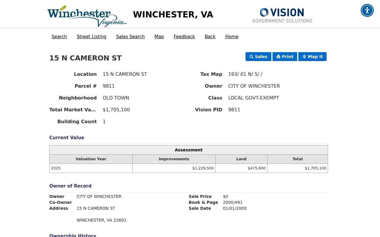
Use the card's tax map, legal description, and book or page clue to carry a street search to the appropriate clerk, then preserve the source and date for every conclusion.
Winchester Street Directory Archive Sources
For an earlier street trail, Handley Archives is the useful fallback after a modern parcel lookup. Its house-history resources connect directories, newspapers, Sanborn maps, photographs, maps, and local records. Winchester photographs are filed by address, while county photographs use a home-name index. The archive's newspaper holdings reach historic papers as early as 1786, and Winchester Star microfilm begins in 1896. Selected local material is searchable through the digital newspaper archive.
Search a street number with and without its directional prefix or suffix. Test abbreviated forms in newspapers and adjacent directory editions. If an old number does not match the present one, compare the deed legal description, tax map, adjoining owners, Sanborn sheet, city minutes, and the building footprint. No official Winchester renumbering chronology was located, so a number-change theory needs evidence rather than a silent conversion.
Winchester Streets Cross Jurisdictions
The Joint Judicial Center at 5 N Kent Street houses the Winchester Circuit Clerk and the Frederick Circuit Clerk, yet the locality choices and subscriptions remain separate. This is a local records quirk, not a minor label issue. Winchester remote land-record access is described from 2006 under a paid subscriber arrangement, and Winchester and Frederick accounts require separate applications. Older instruments and restricted materials still require clerk, archive, or Library of Virginia channels.
Use a city parcel PID only for a city parcel. If city GIS marks an address outside the Corporate Limits, move to Frederick County's assessment and clerk systems rather than forcing it into a city-side result. In-person research at the clerk counter, a precise mail or records request, phone routing, and Handley or Library of Virginia materials are the alternatives when a remote system does not cover the needed item.
Winchester Street Directory Boundaries
A named-street search can point to public property, deed, map, permit, and historical sources. It cannot establish a complete private household list. USPS can validate a delivery address and ZIP, but its own notice says a result does not confirm that a person or business is at the address. An assessment mailing address may differ from the situs address, a directory entry is dated, and a parcel's owner field does not equal a current occupant.
Lawful use. Use Winchester street and address records for legitimate personal research, property history, family history, or civic questions. Do not use them to stalk, harass, intimidate, or harm another person.
For a delivery question, use the official USPS ZIP Code Lookup with the complete address. For a city-held record that is not searchable online, use the Winchester FOIA route or contact the custodian with the address, record type, and date range. Those channels are more reliable than filling gaps with assumptions.